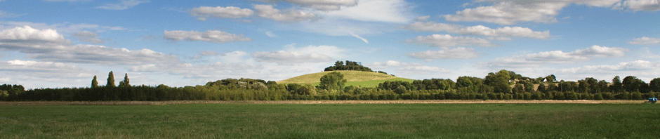
 Nestled along the banks of the Thames, Long Wittenham lies in the Thames Valley in South Oxfordshire under the watchful gaze of Wittenham Clumps, an Iron Age hill fort in our sister village of Little Wittenham. The name Wittenham is believed to originate with the Saxon chieftain Witta. Ham means farmstead in Old English, so ‘Witta’s ham’ would mean the farmstead of Witta. There is an alternative suggestion for the origin of the name of the
village and this comes from the Romano-British word verdonium, or ‘wet-town’, referring to the seasonal flooding and meadows around the river to the northeast of the modern village where the original settlement was located.
Mentioned in the Domesday Survey of 1086, Long Wittenham has a rich history evident as one strolls around the village. Cruck Cottage, one of the oldest houses in South Oxfordshire, is believed to date from the 13th century. There are a number of picturesque timber framed and thatched cottages in the village, as well as an eclectic mixture of more modern buildings, from Georgian houses and post-war ‘Cornish’ housing, to barn conversions and new builds.The nave of the village church, St Mary’s, was built in 1120, and over the next three centuries more elements of the current church were added. It is thought that the church was built on the foundations of an earlier Saxon church; during the early 7th century legend has it that St Birinus preached on the steps of the Village Cross, bringing Christianity to the heathen locals.
The church has one of the smallest iconographic statues in the country, a tiny carved representation of Gilbert de Clare, the Earl of Gloucester and lord of the manor who died in 1295. The timber framed entrance to the church is believed to be around 800 years old, but the history of the village goes back much further than any written records or folklore can recall.
 Long Wittenham has been continually settled since at least the Iron Age, through the Roman period, the Saxon era and into the Medieval period and beyond to the present day. Artefacts dating from the later Palaeolithic period, c. 80,000-30,000BC, have been recovered from the Thames while Neolithic stone tools and Bronze Age burials show human activity and settlement dating back to the 4th millennium BC. An Iron Age and early Roman agricultural settlement to the northeast of the current village was the first archaeological site in the UK to be identified using aerial photographs. The Iron Age pottery recovered from the southwest side of the village can be paralleled with pottery
types from north France and Belgium, suggesting that settlers from these regions made what was to become Long Wittenham their home. Crop marks and limited excavations have revealed an early Romano-British settlement again to the northeast of the current village, and Roman coins and vessels have been discovered here too – the important Roman town of Dorcic (Dorchester-on-Thames) lies only a couple of miles to the east. In the 1860’s a large Saxon burial ground was excavated beneath what is now The Crescent, parts of Westfield Road and Saxons Heath. Over 180 burials or cremations span a period of several hundred years – the local’s conversion to Christianity is evident during the
7th century when burial practices change. The Long Wittenham Stoup, a beaker-like container for holy water depicts biblical scenes carved onto bronze plates and dates from the late 5th / early 6th century AD, before the arrival of St Birinus. The stoup is a very rare and important find, originating from Vermand in northern France and suggesting that at least some of the Frankish raiders that swept up the Thames Valley during this period were Christian, and some of them decided to settle in Long Wittenham.
After the Norman invasion the Domesday survey of 1086 recorded Long Wittenham as being in the hundred of Sutton and was assessed at 13 hides and 1 virgate and was held by Walter Giffard, a second cousin of William I. After the Conquest the village became known as Earl’s Wittenham, being held by the Earls of Buckingham, the Marshall Earls of Pembroke and the Earls of Gloucester and Hertford before it reverted to the Crown in the late 1540s. Thomas White, founder of St John’s College in Oxford, bought up most of
the land and properties in the mid 1550s, along with many other local manors, to endow the college with an income either in rent money or in produce and wood. Recently the College has sold most of the properties and much of the land, although there are still a number of houses and parcels of land, including the allotments that still belong to St John’s College. A large part of the village archive is based in St John’s College with other records held in the Oxfordshire Record Office, although most are held at the Berkshire Record Office in Reading as the parish was in Berkshire until 1974.


For further information on the history of the village and its residents, Long Wittenham History Group meets once a month for talks and research meetings. The group has a good collection of photographs and has transcribed most of the available parish registers. It has published a booklet ‘The Parish of Long Wittenham 1800-1920’ and a series of journals called ‘The Chronicle’, with articles on the shops, church, local characters, farming, buildings, the school and village organisations. These are available to download from the History Group Publications page.
A large scale map of the village was produced in 2012 and amended in 2017, 2020 and 2023. You can view and download a copy here.